[Mapping the Divine: A Journey Through the Sacred Mount Wutai]-[Pilgrimage Map of Mt. Wutai]
📋 Summary
Mapping the Divine: A Journey Through the Sacred Mount Wutai
Introduction: The Sacred Topography
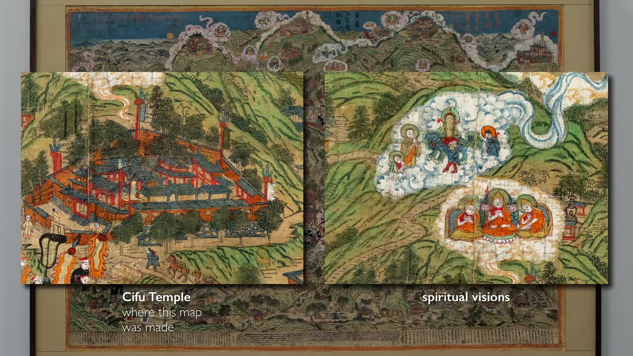
The Rubin Museum’s woodblock print of Mount Wutai offers more than a geographical representation; it serves as a portal into a sacred landscape where the earthly and the divine intersect. Mount Wutai, or "Wutai Shan," meaning "five-terrace mountain," is a cluster of five peaks that has served as the earthly abode of the Bodhisattva of Wisdom, Manjushri, since at least the 5th century. This map functions as a visual record of "divine manifestations," blending the physical reality of monasteries and pathways with the ethereal "cloud-like shapes" containing deities, allowing pilgrims to encounter the divine on Earth.
A Cosmopolitan Site of Pilgrimage
Historically, Wutai Shan functioned as a transcultural hub, drawing Buddhist pilgrims from India, Kashmir, Tibet, Japan, and Korea. The site’s evolution is marked by shifting imperial influences. A significant landmark is the bright white stupa built in 1301 by the Nepalese artist Aniga, Kublai Khan's head of imperial workshops. By the 18th and 19th centuries, the mountain held profound importance for Tibetans, Mongols, and Manchus. The map reflects this by documenting the "Maitreya Festival," a major draw for Mongolian pilgrims, evidenced by the presence of travelers with camels—a detail uniquely associated with Mongolian depictions.
Rituals, Festivals, and Imperial Presence
The map serves as a living document of ritual life. The center of the print depicts a grand procession leading from the Pusading Monastery, identified by its yellow roofs as an "imperial site" since the Qing Dynasty. The procession features the "Jasak Lama," the head of Buddhist Affairs, alongside masked dancers portraying figures such as "bull-headed yama, mahakala and deer." These depictions mirror the actual ritual performances that defined the monastic experience. Furthermore, the inclusion of Mahakala, whose sculpture was used by Kublai Khan during his conquest of China, highlights the deep historical entanglement between political power and religious devotion at Wutai Shan.
Encounters with the Divine: The Folk and the Miraculous
Beyond grand rituals, the map captures the intimate and often whimsical nature of spiritual encounters. One striking scene depicts a folk tale involving the Kangxi Emperor, who fires an arrow at a monk frolicking with two nude women, only to discover the figure is an "emanation of Manjushri." This illustrates the core belief that one might encounter the Bodhisattva "in any form and in anyone" on the mountain. Similarly, the map documents physical sites of transformation, such as a rock crevice where pilgrims are helped through by a midwife, a ritual believed to ensure that those who pass through are "reborn with their sins expunged."
Sectarian Identity and the Tibetan Buddhist Legacy
The map explicitly declares a Tibetan Buddhist identity, specifically aligning with the Gelugpa tradition. Tsongkhapa, the founder of this school and an emanation of Manjushri, appears across the map. The "five different visions" of Tsongkhapa atop the five peaks signify the sectarian depth of the site. This spiritual authority is further cemented by the map's trilingual inscription at the bottom. The Chinese text promises that those who view or print the image will be "free from all calamities and diseases" and accumulate "immeasurable merit."
Conclusion: A Surrogate for the Sacred
Ultimately, this woodblock print serves dual functions. It acts as a "literal guide" for those navigating the actual mountain paths, but it also serves as a "surrogate" for the imagined pilgrimage of those unable to travel. By mapping divine visions onto the physical peaks, the object itself becomes a vessel of grace, ensuring that even in the 21st century, the map remains a powerful tool for spiritual connection, echoing the enduring sanctity of Mount Wutai.

Deep Learning with ListenLeap